The May 1st joint Planning Commission/City Council work session on the 2045 Comprehensive Plan concluded with uncertainty and a clear discomfort with the size of the proposed new Growth Area and the amount of land designated for “Employment Centers” (and identified by the color purple on the land use map).
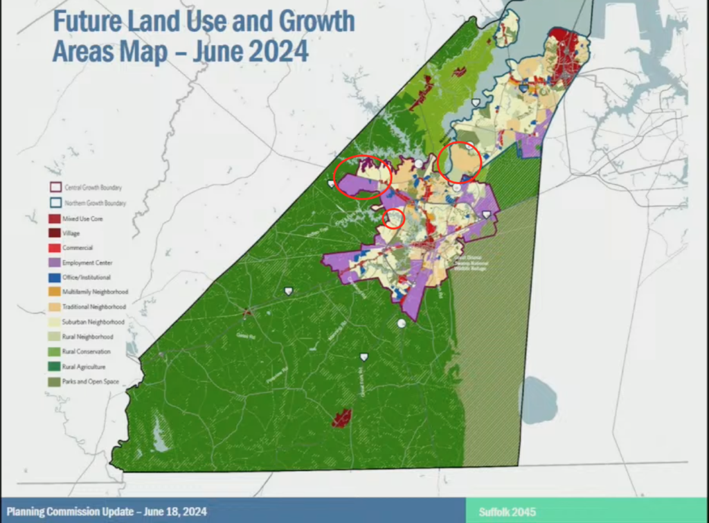
Future Land Use Map June 18, 2024. No longer distinguishes between current and future Growth Areas, so the added Growth Areas have been circled in red by us.
During the recent June 18th Planning Commission Work Session about the 2045 Comprehensive Plan Draft, there was the impression that despite a reduction in the proposed Rt. 460 Growth Area, the amount of purple on the maps is still making people nervous. Planning and city management spent a lot of time trying to provide some assurance about this and presented some new twists on justifying more “Employment Centers.”
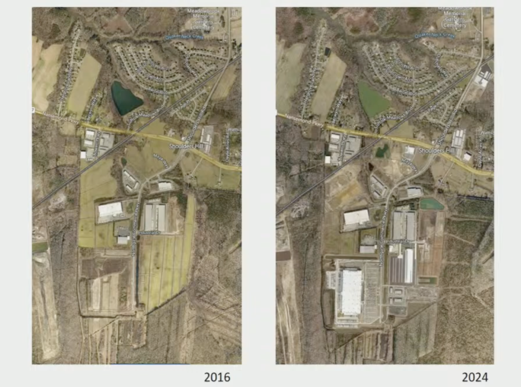
Comparison of warehouse development over time.
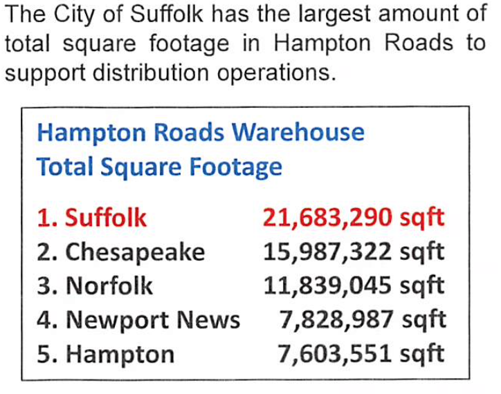
One new tactic was to give sort of a history of warehouse development, showing that the current industrial areas have been built out over time. It seemed they were trying to demonstrate that some of the purple areas within the current growth areas aren’t new and that we need more to support the Port’s needs. What this part of the presentation really demonstrated was how much warehouse space Suffolk already has! We already know we have the most in all of Hampton Roads: 21,683,290 square feet!

Data was presented from March 20, 2024 City Council Work Session Packet, p. 69.
There was also a pie chart to compare the percentages of the Future Land Use Types as they are recommending them. It seemed that they wanted to show that because Rural Agriculture and Parks & Open Space are the highest in percentage versus other land use types, the purple “Employment Centers” are insignificant–nothing to worry about!
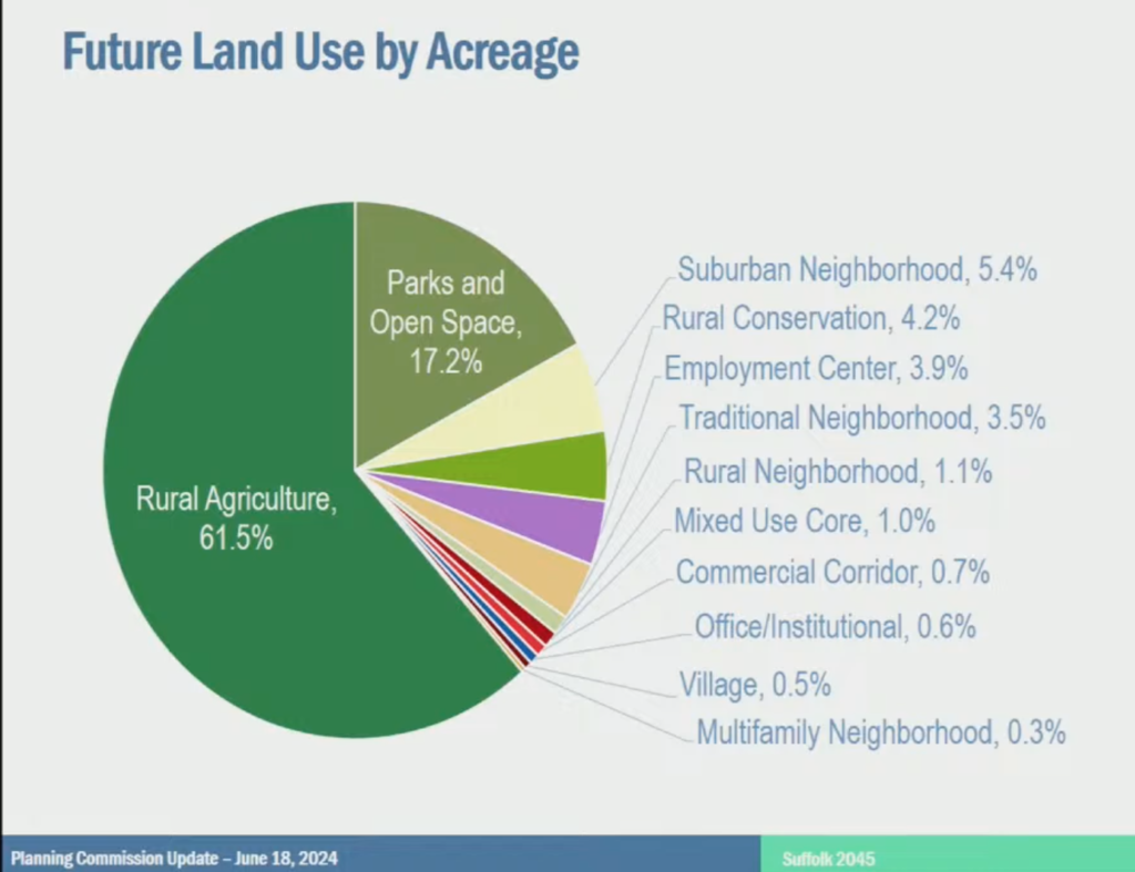
Land Use by acreage - demonstrates that small percentages of intense development can have huge impacts on infrastructure and quality of life.
However, there was no clarification that a lot of land in the Rural Agriculture category are areas that used to fall under the land use types of Forestry and Wetlands, including the Great Dismal Swamp. Another point they never mention is that just because land falls in an agriculture category or zoning, does not mean it’s actually tillable land that can be farmed.
What is really telling with the pie chart though is that it really demonstrates that small percentages of intense development can have huge impacts on infrastructure and quality of life. Most people see and feel this everyday here now (except some city planners and managers, apparently!)
We may have a lot of open space, but our current growth areas are struggling under the recent growth and it seems city planners’ only answer is to continue letting that bleed out into our unprepared rural areas.
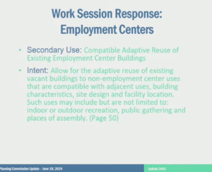
Slide explaining new secondary use of Employment Centers.
Another curious new effort to improve the image of “Employment Centers” is to allow for a new “secondary use” of vacant “Employment Center” buildings (of which there should be none if the need is so great!) This new use is labeled “Compatible Adaptive Reuse of Existing Employment Center Buildings.” It’s simple! The intent is to “Allow for the adaptive reuse of existing vacant buildings to non-employment center uses that are compatible with adjacent uses, building characteristics, site design and facility location. Such uses may include but are not limited to: indoor or outdoor recreation, public gathering and places of assembly. “(Page 50)
The City’s idea is to keep the land use ‘flexible’ by allowing almost any type of non-residential use to go there. This completely contradicts the ‘predictable’ part of the planning they say they are trying to accomplish.
Halfway through the 30-plus slide presentation, there was a somewhat bizarre attempt to focus on talking about Smart Growth. (Actually, not really talking about it so much as just using the phrase.)
We have yet to see one time where anyone who brings up Smart Growth actually explains what it is or specifies any Smart Growth principles they may be referring to. It’s especially odd considering that when you search for the phrase “Smart Growth” in the 2045 comp plan draft it comes up zero times. (Even in the 2026 and 2035 Comp Plans it only comes up a handful of times, and mostly about school facility planning.)
One of the main Smart Growth principles is to contain development where infrastructure is already in place. Two city planners mentioned Smart Growth and then proceeded to talk about extending water, sewer, and road improvements into current agricultural lands, so that they are ready for development which will make them more attractive to developers to build there. That is NOT Smart Growth, that is sprawl!
With each new meeting, the City presents information that addresses what they see as our (the public’s) main concerns. However, they are missing the crux of the issue. The citizens of Suffolk already told the City in the 7,500+ unique comments what we want. Overwhelmingly, people are fed up with the handling of development in the last decade. Instead of actually LISTENING to the citizens, they pat themselves on the back for gathering the comments, and then go on to do more of the same. It is not what we asked for and it isn’t what we want. According to the City Planner giving the presentation, not everyone will be happy with the plan, which is true, but there are clearly other ‘stakeholders’ more important to them than the citizens. The City is intent on making Suffolk a servant of the Port over the wishes of the people.
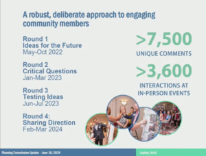
Slide showing the public comments the City received throughout the process.
Please sign our petition to urge City Council to vote ‘NO’ to the new 2045 Comprehensive Plan.