The Comprehensive Plan provides the framework that guides the development of the City of Suffolk for the next several years. Over the last year, the city has been actively seeking community input to help guide what this new plan will look like.
Community Engagement sessions and Open Houses were held throughout the city and during these, the collective voice of the citizens was clear: people were frustrated with traffic and didn’t want any more warehouses. Time after time, the residents from all areas of Suffolk expressed concern that their quality of life was being negatively impacted by warehouses and the heavy truck traffic that comes with them.

Above is a photo from the June 15, 2023 Open House that Suffolk hosted to interact with the public about the proposed plans and obtain feedback. In this snapshot, you can see that the green dot stickers (given to the public to express their opinion) are placed on the ‘thumbs down’ side to show their disapproval of more warehouses in Suffolk.
Fast forward to the January 17, 2024 City Council Work Session: Suffolk’s 2045 Comprehensive Plan Lead Planner, Keith Cannady, gave a presentation about the new Comprehensive Plan draft that included Planning Staff’s recommendations for Growth Area expansion. He touted the opportunities that the Port of Virginia provides. He stated that the Port of Virginia is “changing the dynamic for the state and the region in terms of economic development opportunities” and that this is a “major driver of what’s happening here in Hampton Roads.” He claimed that Suffolk is considering “opportunities that the Port provides as we consider Growth Area boundaries.”
Below are some of the Growth Area slides presented at this City Council Work Session. The corresponding written descriptions reflect what was explained verbally by Mr. Cannady while discussing the slide.
(We apologize for the poor quality; these were screenshot captures from the online work session which were not high resolution to begin with.)
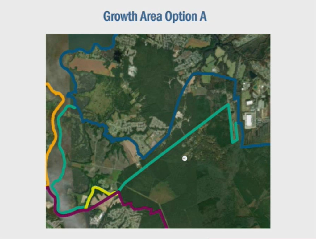
Northern Growth Area Option Slide
The current growth area is within the dark blue border. The only option (Option A) presented for Northern Growth Area expansion is the area within the greenish border. This is the Nansemond Parkway area and would connect the Northern and Central Growth Areas. According to Planning it is “logical” to combine the two and use the railroad as the boundary.
(There is an “Opportunity Area” along I664 that will be discussed at City Council on Feb 7th.)
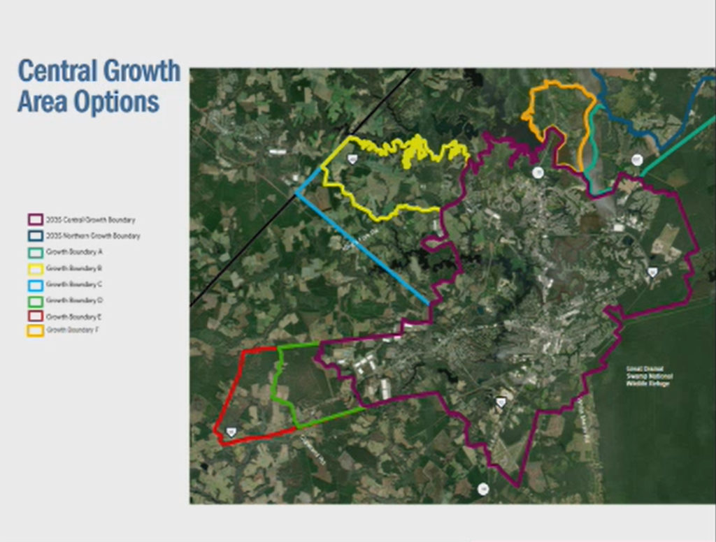
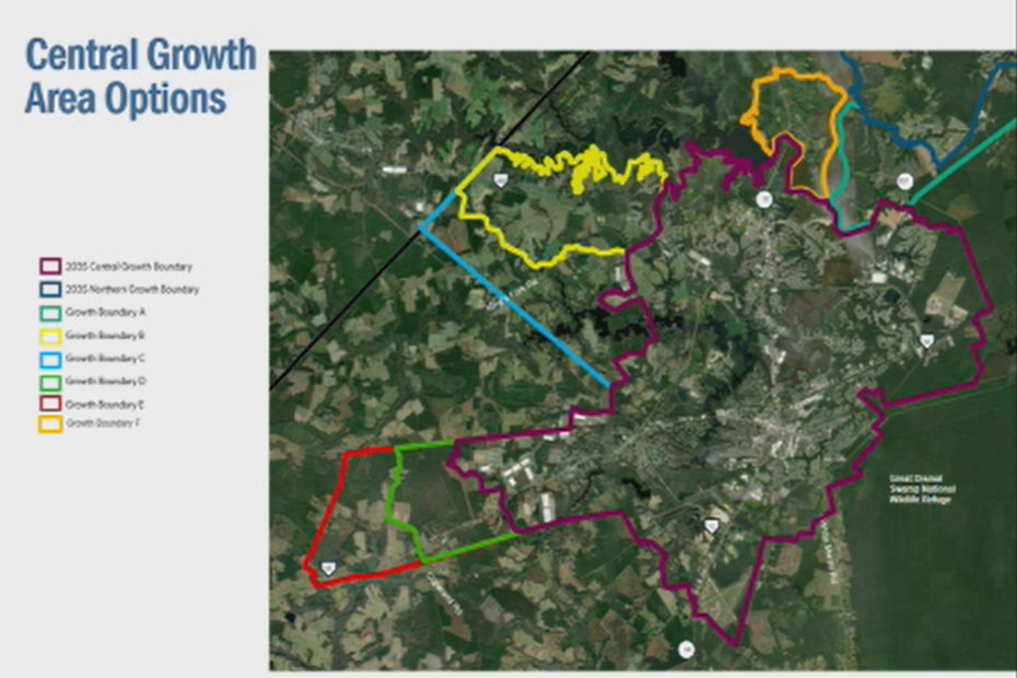
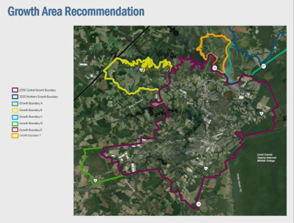
Central Growth Area Options Slide
There are 5 options being considered for expansion of the Central Growth Area. The current Central Growth Area is within the dark purple borders.
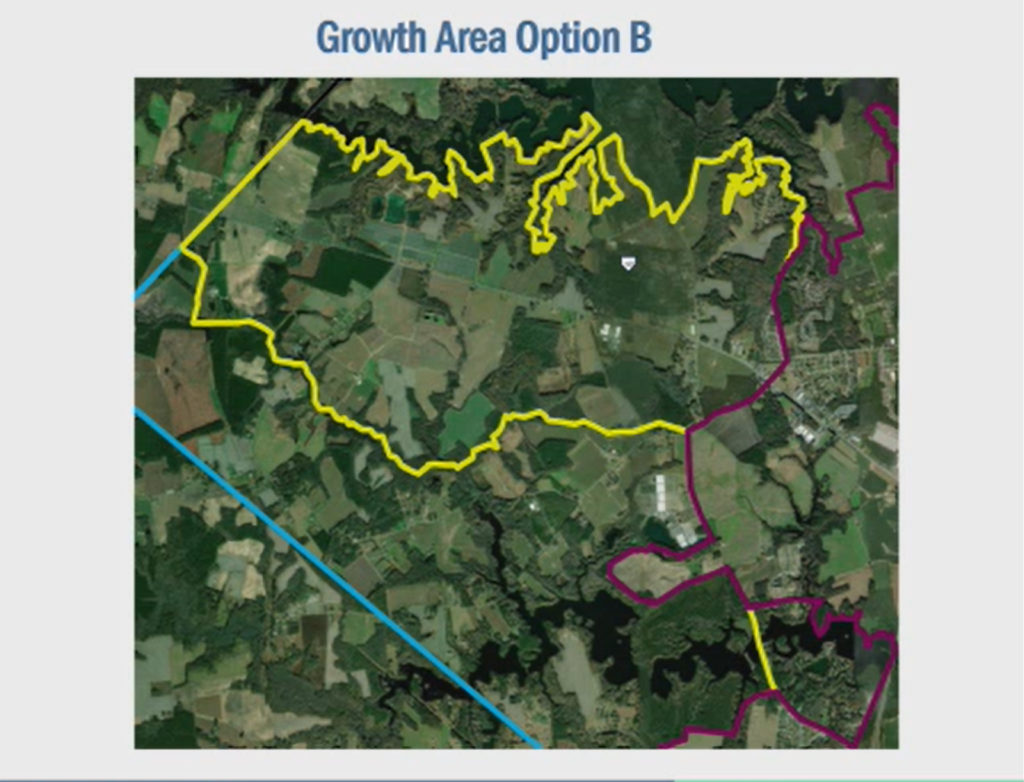
Option B: within the yellow border; expands the current growth area all the way to the city/county line along Rt. 460. The other boundaries would be the Western Branch Reservoir and “a wetland area that forms a logical boundary” to the south.
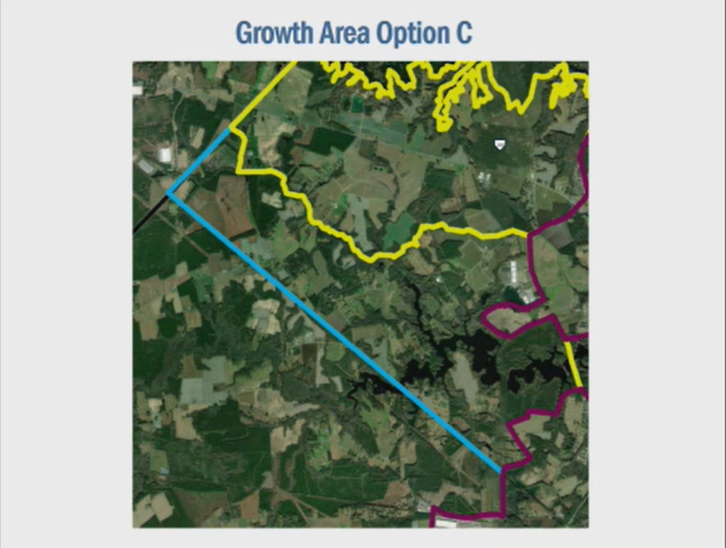
Option C: within the blue border; expands from the yellow border south to the railroad line and includes the Lake Cohoon area.
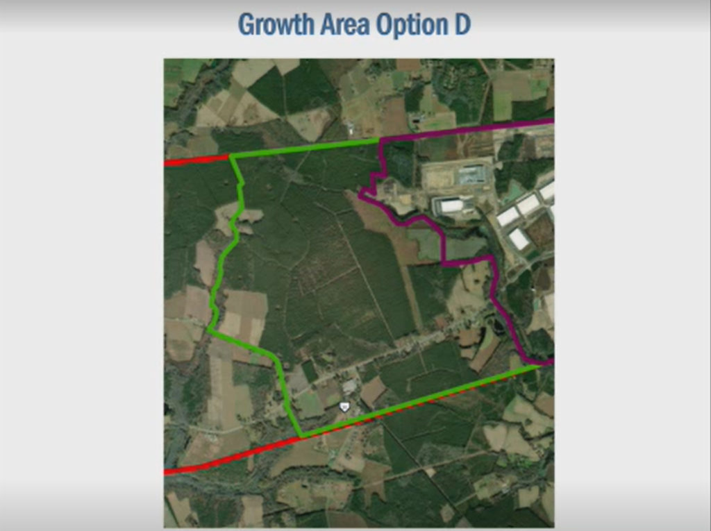
Option D: within the green border; expands west on 58 from the Centerpoint & Westport Commerce Parks down to Chapel Road.
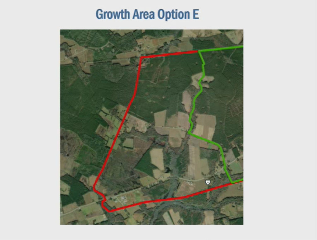
Option E: within the red border; extends down 58 to Buckhorn Road.
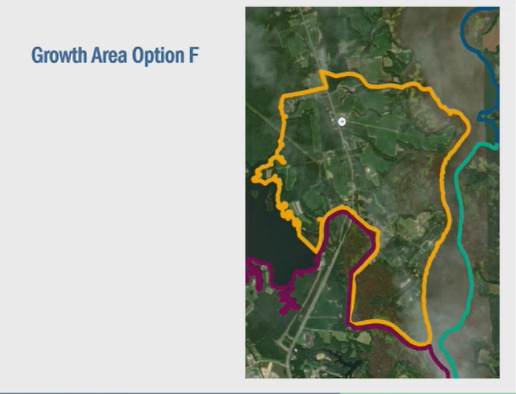
Option F: within the orange border; extends north up Rt. 10/32, including Sack Point Road and up to Kingsdale Road.
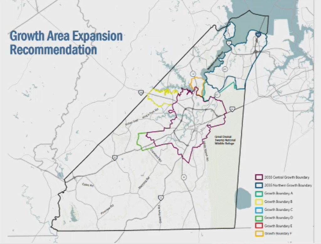
Recommendation Slide:
The Planning Department is recommending that Suffolk incorporate Options A, B, D, and F into the 2045 Comprehensive Plan.
Breakdown of Future Land Use within Growth and Opportunity Areas:
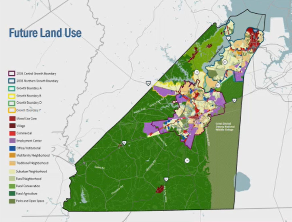
Future Land Use Slide
The City is considering changing/adding new land use categories, listed in the map key on the left side and signified by the solid-colored rectangle. Currently, there are only six or seven land use categories.
Central Growth Area Future Land Use Slide
Within the borders of Option A (within the lighter green border at the top right), Planning is recommending land use categories for residential development.
For the Central Growth Area, Planning is recommending these land use categories:
Option B: residential development to the north of Rt. 460 and “employment center” to the south all the way to the city/county line.
Option D: “employment center” to the north of Rt. 58 and residential to the south up to Chapel Road.
Option F: residential on both sides of Rt. 10/32 all the way to Kingsdale Road.
While making it clear that Suffolk is prioritizing the Port of Virginia, Mr. Cannady provided only vague comments as to the opportunities that justify expanding the Growth Areas to such a great extent. Some of his reasonings were:
- Rt. 460 and 58 corridors offer “what we believe are significant economic development opportunities in that area.”
- Coming south (of Rt. 460) “to a wetland area that forms a logical boundary for that corridor and would allow us to capitalize on some of the options that are out there.”
- Option D “looks to take advantage of some of the opportunities going west out of Rt. 58.”
The recommended Growth Area expansion will total almost 17 sq mi, increasing the current Growth Area (from the 2035 Comprehensive Plan) from about 74.5 sq mi to a total of about 91.5 sq mi. That is an increase of about 23%. That is a lot of growth!
While we expect a certain amount of Growth Area expansion, it hasn’t been made clear how enlarging them to such a great extent specifically benefits the City of Suffolk and its citizens. How much economic benefit will Suffolk see with port expansion growth? This question is not answered.
Adding huge swathes of land (light purple on the Future Land Use map) designated as Employment Centers (warehouses), doesn’t happen in a vacuum. We all want Suffolk to have a vibrant economy, but all those warehouses come at a cost to citizens. They bring truck traffic, higher road maintenance costs, and pollution, as well as destroy forever fertile soil that makes up our agricultural economy, which is itself an economic powerhouse generating $462 million of direct and indirect economic impact for the City of Suffolk. In no uncertain terms, development of warehouses is to the detriment of agriculture in Suffolk. This may be what the Port of Virginia wants, and what the Planning Commission wants, but is it what the people of Suffolk want?
These recommendations go counter to public feedback during the Community Engagement Sessions and Open Houses. Was the city genuine in its efforts to include its citizens in this process? From this presentation, it doesn’t seem like it.
The City has ruined Northern Suffolk’s farm land and destroyed all of the peach orchards and other businesses along Rt 17. So many apartment buildings, but no nice fine or casual dining restaurants can be found!
Now the City is trying to do the same with 58, with warehouses! It’s apparent that they are definitely not listening to the citizens of Suffolk. There is no wonder residents are choosing to move across the lines into NC.
We do not want high-rise apt. buildings or more warehouses!