It isn’t an exaggeration to state that Manning Road is one of the most dangerous and deadliest roads in the City of Suffolk.
The number of accidents, injuries, and fatalities are tracked and the data is available on TREDS (Traffic Records Electronic Data System), one of Virginia’s most effective and innovative information technology tools in the nation to identify and address road safety concerns. The Virginia Office of Data Governance and Analytics has ADT (Average Daily Trip) data available on the Virginia Open Data Portal (most recent data for Suffolk is from 2022).
Below is a chart that shows the comparison of accidents on various roads in Suffolk.
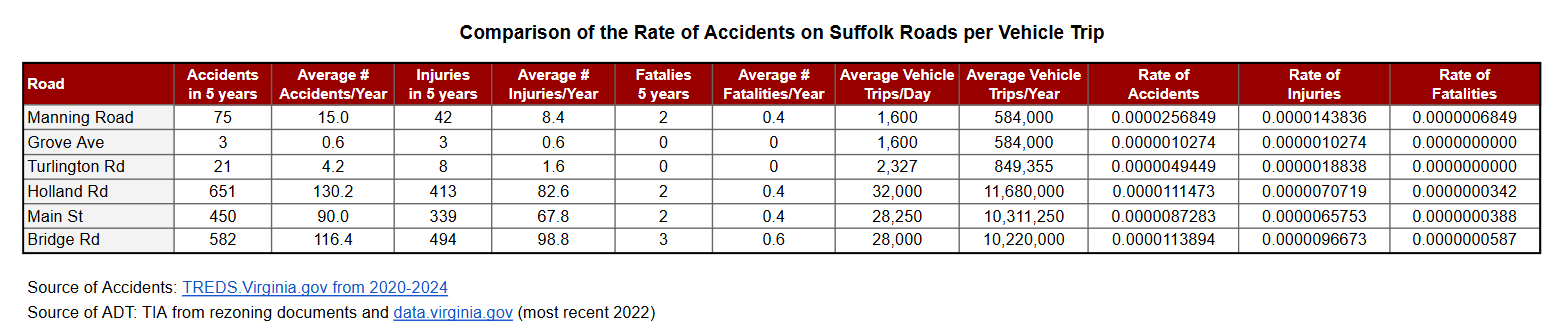
Click on Image of Chart to Enlarge
Manning Road is the location of the proposed Lake Pointe development that will add 300 single family homes and an estimated 2,772 vehicle trips per day. This will bring the ADT from 1,600 to 4,372 trips per day, nearly tripling the amount of traffic.
The chart includes a comparison with Grove Ave because Grove Ave is the location of the traffic study that the developer used instead of conducting one for Manning Road. The developer, with the agreement from city staff, has stated that it is a reasonable substitution. The Grove Ave accident data is from Grove Ave, Northbrooke Ave, and all side streets within that neighborhood combined.
It is expected that busier roads will experience more accidents. Busy roads have much more traffic. To give us a better idea of the safety of a road, we can divide the average number of accidents per year by the average number of vehicle trips per year. This gives us a rate, in this case a very small number because fortunately most drives do not end in an accident. This rate allows us to compare busy main roads to more rural roads and to neighborhood roads. It is similar to how in baseball, they use a batting average instead of the number of hits a batter has had. The batting average is the number of hits divided by the total number of times the player has been up to bat. In this case, the comparison is the number of accidents in a year divided by the total number of vehicle trips.
If you want to know how much more likely it is to get into an accident on Manning Road versus Grove Avenue, you can take the Manning Road Accident Rate and divide it by the Grove Avenue Accident Rate:
Manning Road Accident Rate / Grove Avenue Accident Rate = Likelihood of Accident
0.0000223347 / 0.0000008934 = 25.0
A trip down Manning Road is 25 times more likely to experience an accident than a drive on Grove Avenue. Below is a Comparison Chart that compares the likelihood of an incident to occur on Manning Road compared to other selected roads in Suffolk.
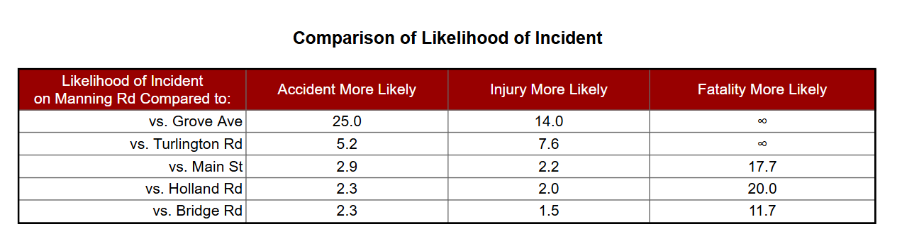
Click on Image of Chart to Enlarge
What this data is telling us is that if you are a driver in Suffolk, you are more than twice as likely to get in an accident while on Manning Road than when you turn onto Holland Road. That seems counterintuitive because there are far more accidents on Holland Road than Manning Road, but there are also thousands more cars traveling on Holland Road every day. For every 1 driver on Manning Road, there are 20 drivers on Holland Road.
Manning Road is one of the most dangerous and deadliest roads in Suffolk. When you turn down Manning Road from Holland Road, you have just increased your chance of dying in a car accident by 20 times. You are 17 times more likely to die on Manning Road than Main Street and 11 times more likely than when driving down Bridge Road. Let that sink in.
When someone from the Manning Road neighborhood tells you that they live on a dangerous road – believe them. The facts support this. It is in fact one of the most dangerous roads in Suffolk.
When the Manning Road neighborhood tells you that this road is far too dangerous to add 300 houses which will almost triple the traffic – believe them. Approving this development is likely to result in more deaths.
There is no plan in the city’s CIP or 2045 Comprehensive Plan to make any improvements to Manning Road – nothing to make the road safer. This development would be about a mile south of the Holland Road/Manning Road intersection. That is a long way to go on one of the city’s deadliest roads. There are no sidewalks, no shoulders, and the lanes are narrow, too narrow to fit large vehicles. Until the city makes improvements to Manning Road to make it safer, no rezonings should even be considered, let alone approved.
This is about preserving lives. Residents of the Manning Road area already risk their lives driving this deadly road daily. The city must not compound this risk by tripling the traffic on Manning Road – one of Suffolk’s most dangerous roads.